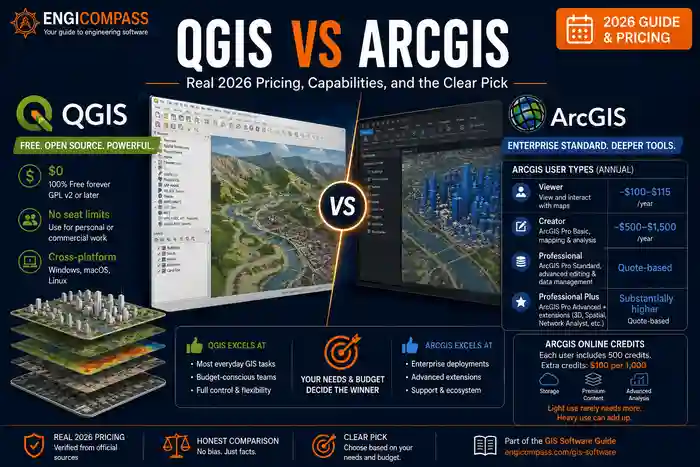
QGIS vs ArcGIS comes down to a real trade-off, not a clear winner. Both are covered in more depth in the GIS software guide. QGIS is free, open-source, and covers the large majority of what most GIS work actually needs. ArcGIS is the enterprise standard — deeper analysis tools, a polished interface, and Esri’s decades of GIS-specific engineering, at a real cost that scales with how much of the platform you need.
QGIS vs ArcGIS — the quick answer:
- QGIS costs $0, licensed under GPL v2 or later, with full commercial use permitted and no seat limits of any kind.
- ArcGIS doesn’t have one flat price. Esri sells it through “user types” that bundle different ArcGIS Pro license levels with ArcGIS Online or Enterprise access — Viewer runs roughly $100–$115/year, Creator (core mapping and analysis) spans a wide $500–$1,500/year depending on deployment and reseller, with the higher Professional Plus tier costing substantially more still.
- ArcGIS’s real edge is enterprise geodatabase management and the depth of Esri’s specialized extensions — 3D and network analysis are closer calls than they first appear, since QGIS has genuine native capability in both.
- QGIS covers the large majority of everyday GIS work competently, including native 3D visualization and network analysis tools that are actively developed, not just plugin-dependent add-ons.
QGIS vs ArcGIS pricing
QGIS is free, full stop. It’s licensed under GPL v2 or later, confirmed directly on QGIS’s own official repository, with commercial use fully permitted and no restriction on seat count, project size, or organization type. It runs on Windows, macOS, and Linux with no licensing server or activation step of any kind.
ArcGIS’s pricing is genuinely more complex than a single figure. Treating it as one flat number is a real, common mistake. Esri sells access through annual “user type” licenses rather than a single ArcGIS Pro subscription. Each user type bundles a specific ArcGIS Pro license level (Basic, Standard, or Advanced) together with ArcGIS Online or Enterprise access:
| User type | Includes | Typical annual cost |
|---|---|---|
| Viewer | View and interact with maps only | ~$100–$115/year |
| Creator | ArcGIS Pro Basic, core mapping and content creation | ~$500–$1,500/year, varies significantly by deployment and reseller |
| Professional | ArcGIS Pro Standard, advanced editing and data management | Quote-based, no published figure |
| Professional Plus | ArcGIS Pro Advanced, plus bundled extensions (3D Analyst, Spatial Analyst, Network Analyst, and others) | Substantially higher than Professional, quote-based |
There’s a real cost dimension beyond the base user-type price too: ArcGIS Online credits. Each user type includes 500 credits, and most everyday activity — viewing basemaps, basic search, exporting data — consumes none at all. Heavier use does draw them down: storage, premium analysis tools, and premium content (like certain Living Atlas datasets) all consume credits, and additional credits cost $100 per 1,000 if you exceed what’s included. For light, everyday use the included 500 rarely matters. For a team doing significant data storage or analysis volume, it’s worth budgeting for as a real, separate line item, not assuming the user-type price is the entire cost.
QGIS vs ArcGIS: what’s the real capability gap?
The gap isn’t in everyday mapping and analysis — both tools handle that well. It’s concentrated in enterprise geodatabase management specifically, where ArcGIS’s tools are more mature and more tightly integrated with the rest of the platform. 3D and network analysis are genuinely closer calls than a simple feature checklist suggests. QGIS has real native capability in both, not just plugin-dependent workarounds.
QGIS covers the large majority of real-world GIS work without specialized enterprise tooling. Network analysis specifically is a case where QGIS is stronger natively than it often gets credit for. Core QGIS already includes built-in network analysis tools for point-to-point routing and service-area calculations, not just plugin-dependent capability. Plugins like QNEAT3 build on that native foundation with more advanced algorithms (isochrone areas, origin-destination matrices) rather than introducing network analysis from nothing. 3D visualization tells a similar story. QGIS’s native 3D Map View is under active, funded development specifically aimed at closing the gap with proprietary GIS software. A 2026 crowdfunding campaign delivered native ESRI Scene Layer support and point cloud processing, both landing in recent QGIS releases.
Symbology is a case worth getting right, since QGIS’s actual reputation here runs the opposite direction from what a feature checklist might suggest. Cartography has long been a genuine QGIS strength. Its symbology engine supports graphic-editor-level control (blending modes, gradient fills, drop shadows), and many professional cartographers prefer it for exactly that flexibility. The real, narrower gap is library size, not engine capability. ArcGIS ships with a larger set of built-in “system styles” out of the box, plus a deep additional catalog searchable through ArcGIS Online’s Living Atlas — QGIS more often means building or downloading a custom style rather than picking from as extensive a built-in collection.
QGIS vs ArcGIS: which should you get?
If your budget is limited or your work is general mapping, analysis, and visualization, get QGIS. It costs nothing and handles the large majority of real GIS work. Its open-source nature also means no per-seat licensing to manage as you scale.
If your organization regularly needs enterprise-scale geodatabase management or Esri’s specialized extension ecosystem, get ArcGIS. Start by identifying which specific user type your team actually needs. Creator is enough for most core mapping and analysis work, and jumping straight to Professional Plus without checking first is a common way to overpay.
Common mistakes to avoid
Comparing QGIS’s price against a single “ArcGIS costs $X” figure. ArcGIS pricing depends entirely on which user type you need — Viewer, Creator, and Professional Plus span a wide range, and quoting one number without specifying which tier isn’t a real comparison.
Assuming QGIS can’t handle professional or commercial GIS work. It’s used in real production GIS work across government, academia, and private industry — per G2’s own reviewer demographics, 28% of QGIS reviewers identify as enterprise-size organizations, not just small teams or hobbyists. The GPL v2-or-later license explicitly permits commercial use.
Buying a Professional Plus user type for work a Creator license would cover. The gap between tiers is real in both price and capability. Confirm which specific ArcGIS Pro license level (Basic, Standard, Advanced) your actual workflow needs before committing to the more expensive tier.
Assuming a capability is missing from QGIS just because it’s not obvious in the default interface. Network analysis and 3D visualization are both native QGIS capabilities, not something you need a plugin just to access at all — check what’s already built in before assuming a plugin search or a switch to ArcGIS is required.
FAQ
Is QGIS good enough for professional GIS work? Yes, for a real share of it. QGIS is used in production GIS work across government agencies, academic research, and private industry, and its GPL v2-or-later license explicitly permits commercial use.
Why doesn’t ArcGIS have one simple price? Esri sells ArcGIS through “user type” licenses that bundle different capability levels with cloud or enterprise access, rather than one flat subscription. The right price depends on which user type matches what you actually do in the software.
What’s the cheapest way to get real ArcGIS Pro access? The Creator user type includes ArcGIS Pro Basic and covers core mapping and content-creation work, typically starting around $500/year direct from Esri but reaching $1,500/year or more through some resellers and deployment types. That’s the standard entry point rather than the Viewer tier, which doesn’t include Pro desktop access at all. Get a direct quote for your specific situation rather than relying on any single published figure.
Can QGIS open ArcGIS files? QGIS can open many common Esri formats, including shapefiles and file geodatabases, directly. More specialized Esri-specific formats or proprietary geoprocessing workflows may not translate cleanly, so test a real file before committing to a full migration.
Does QGIS have a real plugin ecosystem, or is it mostly bare-bones? It’s genuinely large and actively maintained, with plugins covering everything from advanced remote-sensing analysis to urban network modeling — extending native capabilities (like 3D visualization and network analysis, both already built into core QGIS) rather than providing them from nothing. Check the plugin repository directly for your specific use case before assuming a gap exists.